Milborne Port street map
The grid squares are 250 metres across.
Sherborne is 3 miles to the south west, as the crow flies.
Back to Milborne Port (opens in a new tab). Open the map on its own, to zoom in on a phone.
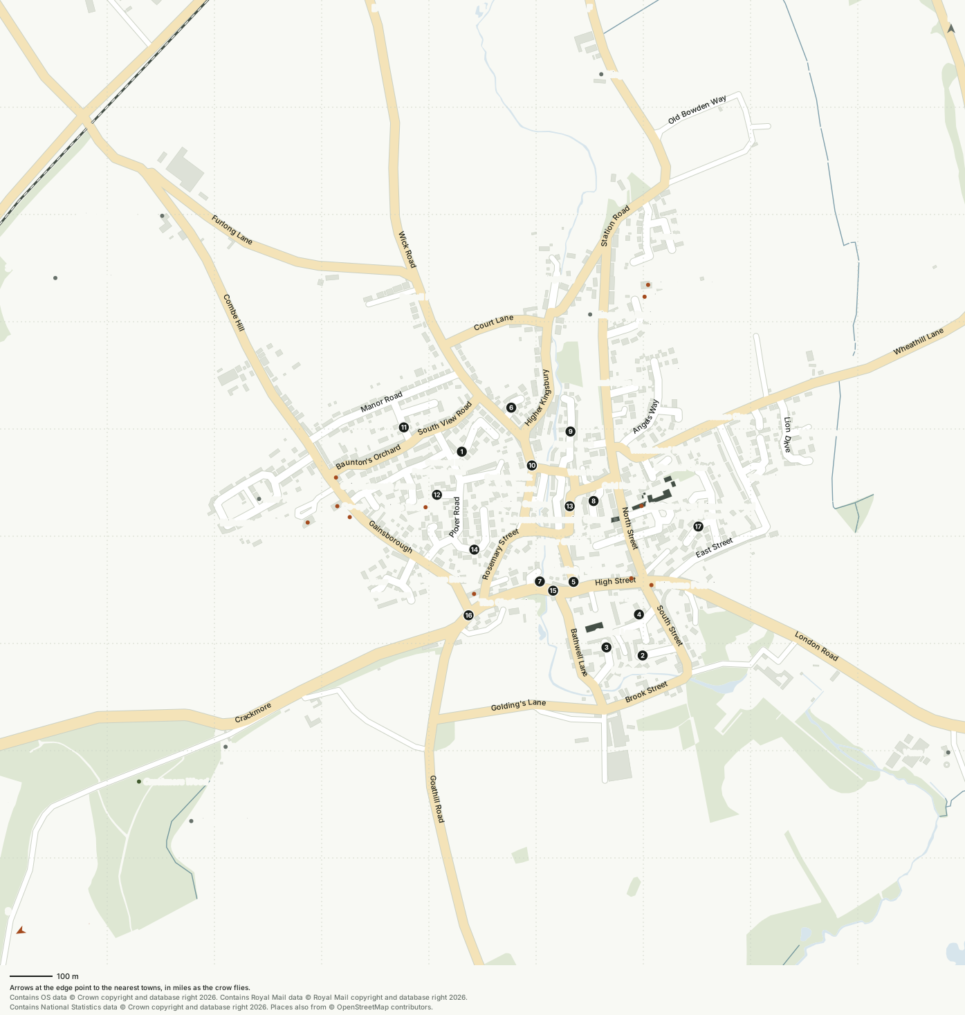
Streets and roads
| Street | Squares |
|---|---|
| Angel Court | F5 |
| Angels Way | F5, G4 |
| Bathwell Lane | F6, F7 |
| Baunton's Orchard | D5 |
| Bauntons Close 1 | E4, E5 |
| Bazzleways Close | F4 |
| Brook Street | F7, G7 |
| Brookside 2 | F7, G7 |
| Cannon Court Mews 3 | F6, F7 |
| Chapel Lane | F6, G6 |
| Church Lane | F6 |
| Church Street 4 | F6, G6 |
| Cold Harbour | F5 |
| Combe Hill | B2, B3, C3, C4, C5 |
| Court Lane | E3, E4, F3, F4 |
| Crackmore | A7, B7, C7, D6, D7, E6 |
| Crackmore Drive | D6 |
| East Street | G6, H5 |
| Everlanes Close | H4 |
| Furlong Lane | A2, B2, B3, C3, D3 |
| Gainsborough | C5, D5, D6, E6 |
| Gascoigne Place | E5, F5 |
| Glovers Close | F5, F6, G5 |
| Goathill Road | E6, E7, E8, E9 |
| Golding's Lane | E7, F7 |
| Gunville Gardens | F5 |
| Hanover View | D6 |
| Henning Way | F3, G2, G3 |
| High Street | F6, G6 |
| Higher Gunville 5 | F6 |
| Higher Kingsbury | E4, E5, F4 |
| Higher Kingsbury Close 6 | E4 |
| Lambert Close 7 | E6, F6 |
| Limerick Close 8 | F5 |
| Lion Drive | H4, H5 |
| London Road | G6, H6, H7, I7 |
| Lower Gunville | F5, F6 |
| Lower Kingsbury | F3 |
| Manor Road | C5, D4, E4 |
| Milborne Gardens | H5 |
| North Crescent | G3 |
| North Street | F5, F6, G6 |
| Old Bowden Way | G1, G2 |
| Old Tannery Way 9 | F4, F5 |
| Orchard Road | E5 |
| Orchard Walk | E5 |
| Paddock Walk 10 | E5, F5 |
| Piece Road 11 | D4, D5, E4 |
| Plover Close 12 | E5 |
| Plover Road | D6, E5, E6 |
| Pope's Lane 13 | F5 |
| Prankerds Road | D5, E5 |
| Pud Brook | F7 |
| Red Wing Road 14 | E5, E6 |
| Rosemary Street | E5, E6, F5 |
| Russell Place | D3 |
| Sansome's Hill 15 | E6, F6 |
| Sherborne Road 16 | E6 |
| South Street | G6, G7 |
| South View Road | D5, E4, E5 |
| Springfield Road | F3, F4 |
| Station Road | F1, F2, F3, F4, F5, G2 |
| Streamside Walk not named on the map | F5 |
| The Brambles not named on the map | F4 |
| The Grove not named on the map | F6 |
| The Meads 17 | G5, G6 |
| Thimble Lane not named on the map | G6 |
| Vartenham Close | D6 |
| Wellington Close | G4 |
| West Hill | E5, F5 |
| Wheathill Close | F5, G5 |
| Wheathill Lane | F5, G4, G5, H4, I1, I3, I4 |
| Wheathill Way | G4, G5, H5 |
| Wheatsheaf Road | F5 |
| Wick Road | D1, D2, D3, E3, E4, E5 |
| Wilson Close not named on the map | G5 |
Places
| Place | What | Square |
|---|---|---|
| Big Rec | Playground | G3 |
| Co-op | Shop | D5 |
| Crackmore Lodge | Named place | C7 |
| Gainsborough Arms | Pub | D5 |
| Higher Coombe Farm | Farm | B3 |
| Highmore's Hill | Named place | B8 |
| Kingsbury Farm | Farm | F1 |
| Kingsbury Regis | Named place | F3 |
| Little Rec | Playground | D5 |
| Milborne Port Library | Library | G6 |
| Milborne Port Pharmacy | Pharmacy | F6 |
| Milborne Port Primary School | School | F5 |
| Milborne Port Surgery | Surgery | C5 |
| Milborne Port Village Hall | Village hall | G3 |
| New Town | Named place | C5 |
| Reborne Community Church | Church | F5 |
| St John's Church | Church | F6 |
| The Clockspire | Restaurant | E6 |
| Tippling Philosopher | Pub | F6 |
| Top Rec | Playground | D5 |
| Vartenham Hill | Named place | A3 |
| Venn Farm | Farm | I8 |
| Wayne Pullen | Shop | F6 |
Drawn on 17 September 2026 from Ordnance Survey open data, under the Open Government Licence (opens in a new tab), and OpenStreetMap, under the Open Database Licence. Only houses and farms Ordnance Survey names are shown. Something missing or wrong? Email hello@heathfold.uk.
Contains OS data © Crown copyright and database right 2026. Contains Royal Mail data © Royal Mail copyright and database right 2026. Contains National Statistics data © Crown copyright and database right 2026. © OpenStreetMap contributors (opens in a new tab).